
 Twitter Updates
FOOLING OURSELVES – Page 2
By focusing on individual storms, the project produces much more detailed and accurate estimates of soil erosion than the statewide average annual estimates produced by the National Resources Inventory.
The picture that emerges is alarming.
In 2007, the project estimated that storms resulted in rates of soil erosion in some townships ranging up to more than 64 tons per acre per year. That figure is 12 times greater than the statewide average annual erosion rate of 5.2 tons per acre per year estimated by the Inventory. The project estimates that agricultural fields in 440 townships encompassing 10.1 million acres may have suffered erosion at rates greater than the NRI statewide average and that eight townships encompassing 184,000 acres experienced utterly disastrous average erosion rates exceeding 50 tons per acre (Figure 1).
Figure 1: Millions of acres in Iowa eroded at more than 5 tons per acre — the so-called “sustainable” rate — in 2007.
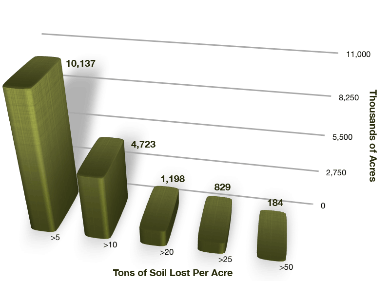
Source: Iowa Daily Erosion Project
The Iowa Daily Erosion Project is a collaboration of scientists at Iowa State University, USDA’s National Soil Erosion Research Lab, USDA ‘s National Laboratory for Agriculture and the Environment and the University of Iowa (http://wepp.mesonet.agron.iastate.edu/). The project is designed to produce daily estimates for rainfall, runoff and soil erosion for the State of Iowa.
Statewide erosion averages — by necessity — provide a very poor picture of what is actually happening across large areas of Iowa or any other state or region. The statewide average erosion for agricultural land in 2007, according to IDEP data, was only 4.7 tons per acre — less than the amount reported by the 2007 Inventory.
The statewide average was low despite the likelihood that agricultural land in 440 townships encompassing more than 10 million acres eroded at more than the “sustainable” rate, and land in 220 townships encompassing almost 6 million acres likely eroded at twice the “sustainable” rate (Figure 2).
Figure 2: Millions of Iowa acres eroded faster than the “sustainable” rate in 2007.

Iowa and its neighboring states experience multiple erosive rainfall events each year. Adding up the erosion that likely occurred in each storm reveals that erosion frequently exceeds the “sustainable” level — often by several times — in many townships.
Figure 3: Townships (36 square miles) where average erosion exceeded the “sustainable” rate
| Year | > 5 Tons | > 10 Tons | >20 Tons | > 25 Tons | > 50 Tons |
| 2002 | 360 | 126 | 25 | 11 | 0 |
| 2003 | 100 | 22 | 2 | 2 | 1 |
| 2004 | 184 | 48 | 1 | 0 | 0 |
| 2005 | 26 | 3 | 0 | 0 | 0 |
| 2006 | 0 | 0 | 0 | 0 | 0 |
| 2007 | 440 | 205 | 52 | 36 | 8 |
| 2008 | 606 | 305 | 84 | 44 | 3 |
| 2009 | 641 | 395 | 160 | 117 | 30 |
| 2010 | 133 | 41 | 8 | 3 | 0 |
Source: Iowa Daily Erosion Project
As Figure 3 shows, average soil erosion exceeded the “sustainable” rate in some townships every year except 2006. Agricultural land in six townships (encompassing about 138,000 acres) risked absolutely disastrous average erosion rates exceeding 100 tons per acre.
From early spring to the beginning of July, intense rainstorms, many of which are localized, cause extensive rill and gully erosion on Iowa farm fields. Such large erosion events are random. They don’t happen every year, but when they do, they are significant. Even when experts declare average soil loss to be less than the soil loss tolerance or “T” value, some places are losing significant amounts of soil.
Only soils with dense vegetative cover are completely protected from soil erosion, and corn-bean ground is virtually bare from November through the end of June, when the crop canopy begins to close up. Even with no-till, terraces, grassed waterways, and all the other best management practices (BMPs), we can’t escape this fact.
High-intensity rainstorms are predicted to increase in frequency because of climate change. Iowa must thus confront the potential for even more soil erosion if it is to attempt to reduce flooding and begin to improve water quality in the state’s lakes and streams.
Laura L. Jackson, Professor of Biology
University of Northern Iowa, Cedar Falls


